Grab the rain gear this morning!
THE FORECAST:
Today and Tonight: Monday, we start off the week with much more rain. As we move through the afternoon hours, rain coverage will become more widespread. Most of us will see some rain today. When it’s not raining, it will be cloudy and temperatures will climb to near 86 degrees. Some showers may linger into the overnight hours keeping lows near 74.
Up Next: Tuesday will be rainy too, similar to today with highs near 87 degrees. Showers and storms will become less widespread on Wednesday and more isolated by Thursday. Through the week highs will slowly climb back into the mid 90s by the weekend.
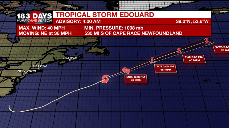
The Tropics: Tropical Depression Five was named Tropical Storm Edouard late on Sunday night. Edouard is located far off the east coast of the US and is moving northeast at 36mph. The maximum sustained winds are near 40mph and little to no change in strength is in the forecast. Edouard will likely become post-tropical later late Monday.
Closer to home, a small low pressure in the Gulf of Mexico near the Florida Panhandle is associated with disorganized thunderstorm activity. Though significant development is unlikely, the low is expected to become more defined as it moves northeast toward the Carolinas. The main threats with this system are increased storm activity in the impacted areas.
Additionally, a strong tropical wave, centered about 650 miles east of the Windward Islands, is producing disorganized showers and thunderstorms. Some slight development of this system is possible today before environmental conditions become hostile for development on Tuesday. The wave is forecast to move through the Lesser Antilles on Tuesday and could produce locally heavy rainfall as well as gusty winds on some of those islands. Formation chance through 48 hours...low...10 percent. Formation chance through 5 days...low...10 percent.
THE EXPLANATION:
Our viewing area is situated on a boundary between two ridges. This is creating ample instability and lift for prolonged showers and storms for Monday and Tuesday. A ridge that is currently over the 4 Corners will start to dig and expand eastward toward us on Wednesday. This will increase subsidence and bring dry air further east. Rain chances and coverage will slowly decline as this dry air moves in. 500 mb heights are also expected to increase. Temperatures will climb well into the 90s by the end of the week.
--Marisa
The WBRZ Weather Team is here for you, on every platform. Your weather updates can be found on News 2, wbrz.com, and the WBRZ WX App on your Apple or Android device. Follow WBRZ Weather on Facebook and Twitter for even more weather updates while you are on the go.
0205064XiQ???9
"activity" - Google News
July 06, 2020 at 06:04PM
https://ift.tt/2D8cvXu
The rain continues, activity in the tropics - WBRZ
"activity" - Google News
https://ift.tt/3ddCXMh
https://ift.tt/2WkO13c
Bagikan Berita Ini


0 Response to "The rain continues, activity in the tropics - WBRZ"
Post a Comment